
Historical development
The south-west expansion of Norwich in the mid-19th Century, in maps
Town Close Road and its adjacent lanes contain some 20 listed Grade II buildings and sits centrally within the Newmarket Road Conservation Area. Such a concentration and the consistency of unspoilt heritage properties from a single period is unique within Norwich. In central Norwich there are many fine streets, some dating back to medieval times and long before early Victorian construction began in the Town Close area. But few locations in the city have retained the homogeneity of Town Close Road. Furthermore, most of the plot boundaries and gardens here contain fine mature trees, many dating to the mid-nineteenth Century when these buildings were first constructed.
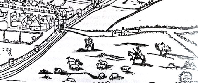
From map of William Cuningham 1558. The Town Close area was agricultural land outside the city walls until the 1830s. The northernmost tip of the Town Close triangle can be seen on the right.
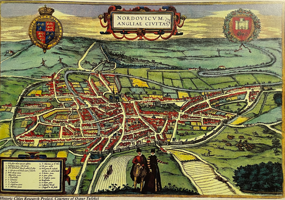
Braun and Hogenberg’s map of Norwich 1582. The junction of Ipswich and Newmarket roads can be seen on the far right surrounded by countryside. The Town Close area was agricultural land outside the city walls until the 1830s. The northernmost tip of the Town Close triangle can be seen on the right.
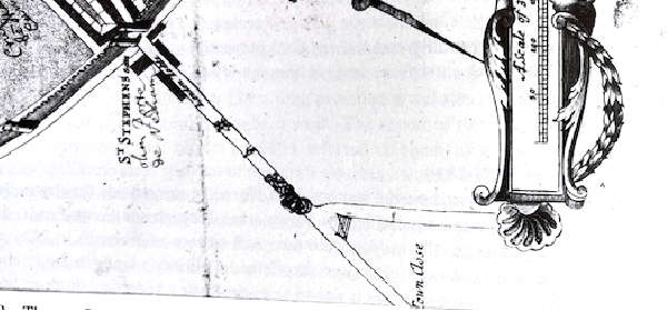
Detail of the junction from map of Thomas Cleer 1696. In the late 17th Century, ‘Town Close’ is marked on this 1696 map, along with the barred gate at the Ipswich Road / Newmarket Road junction. In the late 18th Century, a windmill stood within the triangle.
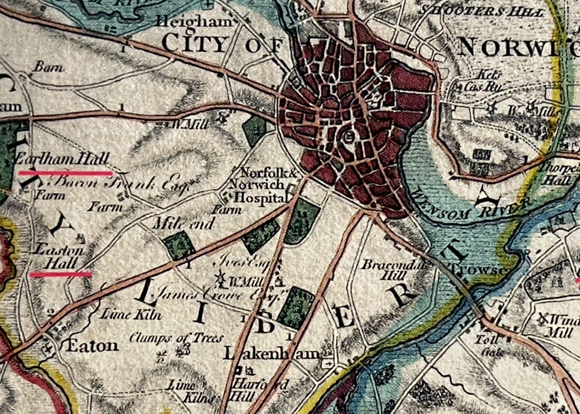
From Faden’s Map of Norfolk 1797. Note the windmill close to where Town Close Road now stands.
“Between 1791 and 1810 the city gates and large sections of the wall were removed because they were considered to make the city unsanitary and were impeding access. Although existing suburbs existed at Heigham, Bracondale and Pockthorpe in the 18th Century, much larger areas of housing were developed outside the remaining city walls during the 19th Century, particularly for the middle and artisan classes…. White brick buildings became popular in Norwich from the early to mid-19th Century. George Gunton’s Costessey Works (to the NW of the city) produced bricks from the 1830s up to World War 1’”
[Source Norwich City Council Conservation Area Appraisal, Sept 2007]
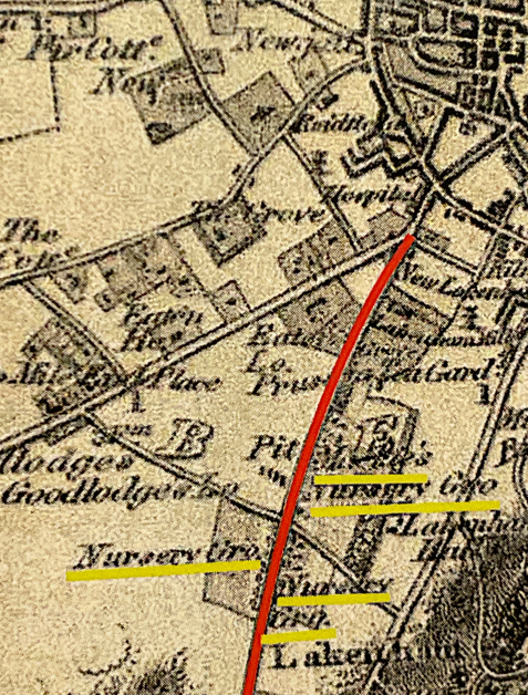
From Bryant’s map of 1826, showing Eaton Lodge as well as the three Mackie nursey sites on Ipswich Road to the south and east of the current Town Close Road area. These covered 100 acres and was one of the largest provincial nurseries in the country (Back Stories p155)
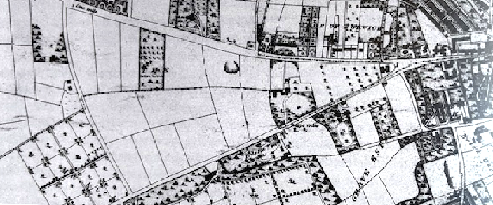
From Map of Josiah Manning 1830. Nursery gardens proliferated in the area at this time, still outside the city but close by.
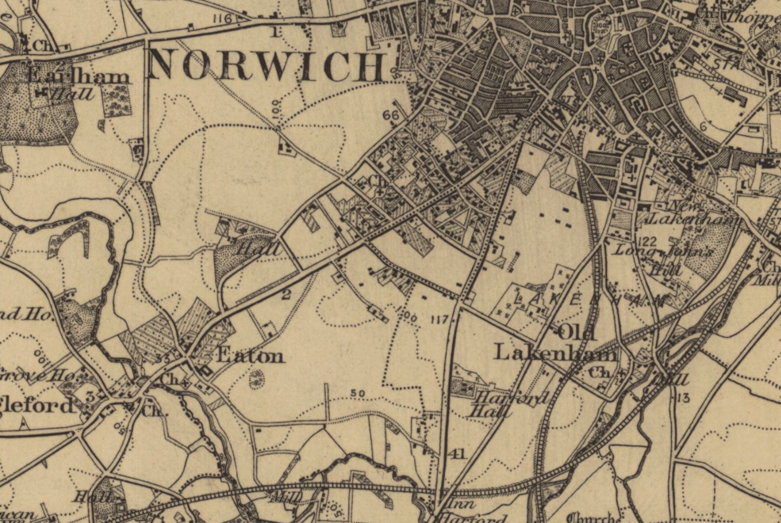
Detail from OS map of Norwich Sheet 161, surveyed 1880-83. This shows that the Town Close Road area was at that time on the very edge of the city’s development, with agricultural land to the east and south. This remained the case right up to the end of WWII.
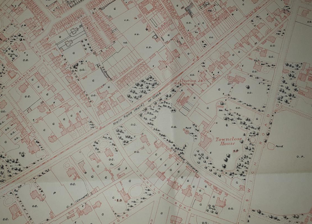
From Ordnance Survey ‘Corrected’ map 1885, now showing in detail the new houses of the Town Close Estate in bottom centre.
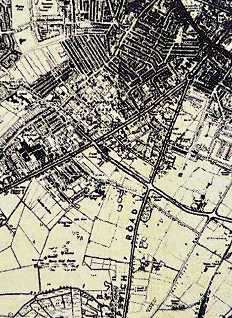
1945 From Norwich City Plan (from Norfolk Record Office)
The Town Close Estate
The heritage buildings of the Town Close Estate were built and owned by the Freemen of Norwich, who have a long and interesting history. Quoting from the Town Close Estate Charity (now Norwich Freemen’s Charity) website:
“The Norwich City Charter of 1406 gave the Freemen of Norwich the power to set up a system of Self-Government. Aldermen and Councillors were all Norwich Freemen, elected by Freemen whose aims at the time were to promote and protect their freedom to trade. At that time, admission to the Freedom was either by being the son of a Freeman or by virtue of being apprenticed to a Freeman for seven years. The 1835 Municipal Corporation Act effectively removed this system and replaced it with the modern system of Government.
In Norwich, the Freemen still laid claim to the Town Close Estate, which is the triangle of land bounded by Newmarket Road, Ipswich Road and Eaton Road. By 1887 the title was given to the Freemen. In 1892 the Charity Commission established the Norwich Town Close Estate Charity now known as The Norwich Freemen’s Charity. By the 1920s the Norwich Freemen were actively managing the estate to increase the income to The Norwich Freemen’s Charity for the benefit of the less well-off Freemen.
In 1979, following the Leasehold Reform Act of 1967, the Trustees sold a number of the properties and invested the return in commercial property, a policy which by the mid-1980s had greatly increased the Charity’s income. Today the Charity gives financial help in the form of educational grants, relief in need grants and pensions to Freemen, their children and their widows and surplus income beyond these demands goes to registered charities with an educational purpose within a 20-mile radius of the Norwich Guildhall.”
The building of the Town Close Road area (1852 -1872) and first occupants
It is difficult to be precise about dates for the construction of the individual houses in the Town Close area. Elizabeth Griffiths and Hassel Smith’s publication Buxom to the Mayor, A History of the Norwich Freemen and Town Close Estate shows the area between Town Close Road and Lime Tree Road was developed in Phase II of the Town Close Estate’s development between 1852 and 1872. This was a period of major growth for the Estate which increased from 20 houses in 1851 to 51 houses in 1872. Morant’s Map of Norwich 1872 (see below) shows the layout of the 1852 developments. It is reasonable to suppose that most of the houses in the Town Close area date from the years in the period after the 1852 decision to offer these plots for sale.
The History of Norwich Freemen publication describes the lives of the occupants of the Town Close Estate house in the 19th Century as “solidly middle class and usually elderly”, but with the leading names of Norwich life at that time missing. This statement is however much contested. The leading Norwich architect Edward Boardman lived at Town Close House, and other houses were occupied by leading merchants and professionals from the city. By the 20th Century there were an increasing number of doctors and consultants, working at the nearby Norwich Hospital at the top of Newmarket Road (relocated to the new site at Colney in 2001-03). Renting (in this case from the Estate) was at that time a common form of residency, and only in recent decades have owner-occupied properties become the norm. By 2024 the Town Close Estate (now the Norwich Freemen’s Charity) only owned (and were renting out) four of the properties in this area.
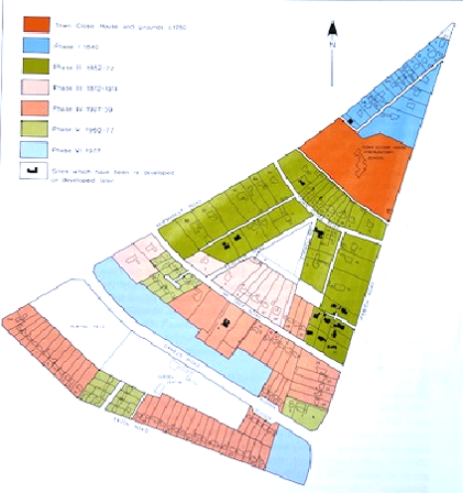
The area shown in dark green, which covers Town Close Road and adjoining lanes, was planned as Phase II of the Estate’s development 1852-72.
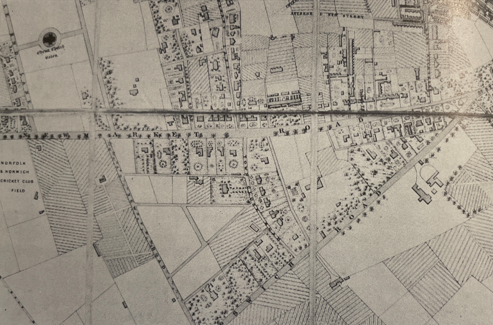
From Morant’s Map of 1872, showing the early sections of Town Close Estate.
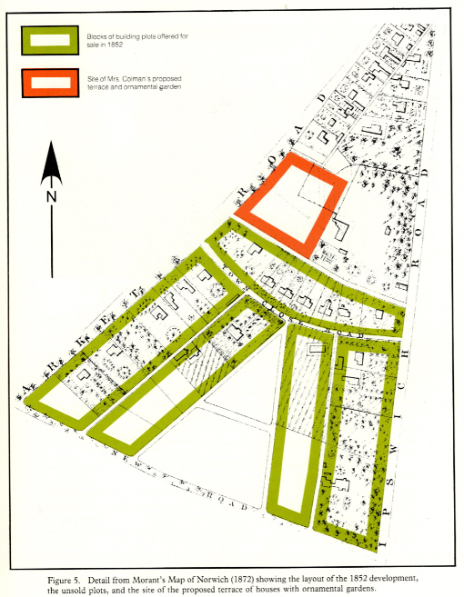
From Morant’s Map of Norwich 1872. The green blocks had been offered for sale in 1852. New Road (at the bottom of this map) is now named Lime Tree Road.
The Ipswich Road – Newmarket Road Apex
The photos below are included here as they show street scenes for the late 19th and early 20th Centuries and give an idea of the character of this area at that time.
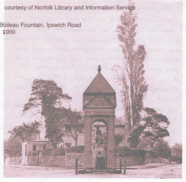
Boileau Drinking Fountain ‘for people and cattle’ on the corner of Newmarket Road and Ipswich Road.
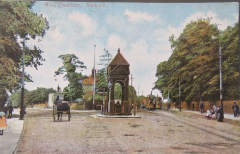
This was designed by Thomas Jeckyll in 1870 and built in 1876.
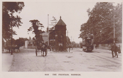
The fountain was only demolished in the 1960s to facilitate traffic flow.